Tools and Methodologies
Like all scientists, Caryn and Katie use a variety of tools and methodologies to gather and analyze their data.
Point Transect Surveys
One of the objectives of the research is to document where manatees are found in the study area. This is done by
conducting point transect surveys. Point transects are "points" that are distributed evenly throughout the study area. Katie and Caryn selected these points when they first began their research. Each point is visited by boat on a regular basis by the researchers and their team. Katie and Caryn stay at each point for 30 minutes and look for manatees. Every time they spot manatees they record the location and how many manatees are present. This allows them to establish where in the study area manatees are found on a regular basis. They then investigate these areas more closely for the presence of suitable food and fresh water for the manatees.
Global Positioning System (GPS)
Katie and Caryn use a GPS to locate scan points and to record the location of any manatees they happen to see (called opportunistic sightings) while traveling between scan points. A GPS is a hand held device that communicates with at least 3 satellites simultaneously to determine an exact location on the earth in degrees longitude and latitude. The GPS runs off a 12-volt battery or AA batteries.
Range Finder Binoculars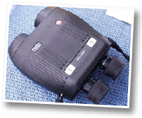
Range finder binoculars are used to determine the distance from the boat to any manatees that are found. The user takes a bearing on the manatee (usually the manatee's nose) by pushing the button on top of the binoculars activating a laser. When the button is pushed again, the finder gives a readout of the distance from where the user is standing to the manatee.
Underwater Digital Video Camera
Katie and Caryn use an underwater digital video camera to take pictures of individual manatees. This allows them to determine if individual manatees are resident or transient and how they use the study area.. They also compare their pictures with pictures other scientists have taken in other parts of the country to determine where the manatees may be traveling to and from. This helps them understand how individuals may be traveling about the country.
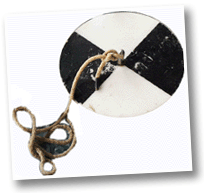
Quadrates and Corers
Quadrates and corers are used to sample the seagrass beds. Using the corer, we can determine the amount of grass that is present in terms of biomass. Biomass is simply how much living matter is in a system measured by weight. The
corer also allows us to gather samples to test for nutritional content. Using plastic quadrates, Caryn and Katie can estimate the percentage of the bottom that is covered by seagrass, determine the density of individual plants and determine the relative abundance of each species.
Environmental Measurements
Katie and Caryn use a variety of instruments to record data about the environment.