Friday, August 30, 2002
![]()
"Tropical storm Dolly forming 700 miles southwest from Cape Verde Islands
located off the coast of Africa." We will pay attention to this
one over the next few days.
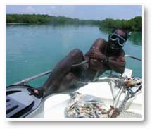
After a breakfast of scrambled eggs, refried beans, and tortillas, we loaded
the boat and headed out. The dogs were into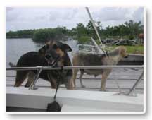 everything. When we pull away from the dock in the mornings they howl and
sometimes jump in the water and swim along with us until they tire and head
for shore.
everything. When we pull away from the dock in the mornings they howl and
sometimes jump in the water and swim along with us until they tire and head
for shore.
South Gallows Reef
Our destination today—South Gallows Reef for manatee scans and snorkel
practice. Our first stop out though is to record weather conditions. Our
second day and we are already pros at taking air and water data. Of course,
this is the easy part!
Legend has it that Gallows Reef was named after a point on the closest caye
where the hanging gallows used to be located. Originally the gallows were
located in Belize City but were moved so as not to upset the citizens of
Belize City with the sight of public hangings.
FYI: We are 5,052 miles from our research station in Ankasa, Ghana. Kevin
carried his GPS (global positioning system) with him to both Ghana and Belize.
He can mark our various locations with it and the GPs will compute the distance
between locations.
Like yesterday, on our way out, we saw a dolphin as we traveled. The water
was so clear we could see the dolphin as it swam under and around the boat.
It seemed to be playing with us a bit. Unfortunately, we didn’t get
our cameras out in time and missed a great picture.
 After
ending our dolphin break, we continued our survey towards South Gallows
Reef. A survey is when the boat is moving slowly and we are looking for
manatees. If we see one we stop and observe it for a period of time. A scan,
on the other hand, is a thirty minute period of time where we stay in a
stationary position and continually visually scan the water around the boat
for manatees. Scan points are predetermined by Katie and Caryn and they
regularly come back to these locations to observe manatees. By looking at
data taken over a period of time they can begin to predict the presence
or absence of manatees in certain types of areas.
After
ending our dolphin break, we continued our survey towards South Gallows
Reef. A survey is when the boat is moving slowly and we are looking for
manatees. If we see one we stop and observe it for a period of time. A scan,
on the other hand, is a thirty minute period of time where we stay in a
stationary position and continually visually scan the water around the boat
for manatees. Scan points are predetermined by Katie and Caryn and they
regularly come back to these locations to observe manatees. By looking at
data taken over a period of time they can begin to predict the presence
or absence of manatees in certain types of areas.
In the Amazon our scans consisted of counting dolphins from a moving boat.
We would move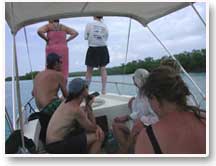 at a speed that was just slightly faster than the dolphins could swim. That
way we could ensure that we were not counting the same dolphins more than
once. Here we scan when the boat is stationary making it difficult sometimes
to determine the actual number of manatees present.
at a speed that was just slightly faster than the dolphins could swim. That
way we could ensure that we were not counting the same dolphins more than
once. Here we scan when the boat is stationary making it difficult sometimes
to determine the actual number of manatees present.
When someone spots a manatee they try to describe its location to the rest
of us. When we are surrounded by mangroves on all sides it can be difficult
to come up with any kind of helpful description. “It is over there
by the mangroves where the water meets the sky” just doesn’t cut
it. Instead we get quite creative in describing the slightest variation
in the water and the mangrove shoreline. “See the third root clump
from the end of the caye that is about 1 foot from the waterline beyond
where the water becomes glassy”, is ultimately more helpful. We also
use a clock analogy with the bow of the boat as 12 o’clock and the
stern as 6 o’clock.
Once we arrive at the reef we began our scan. Today we anchored just inside
the Belize Barrier Reef. The reef is the second largest barrier reef in
the world. Caryn is very careful when dropping the anchor so as to not damage
the reef below. Gilroy always drops the anchor in large sandy patches. She
is also careful not to disrupt sand because it can kill the living coral
organisms. Anchoring by careless boaters causes a great deal of damage to
the reefs.
Water Spouts
 Unfortunately,
there were no manatees at South Gallows Reef, or at least none that we observed.
After our 30 minute scan we got into the water to snorkel around the reef.
Katie gave us a talk on snorkeling safety. For those of us new to snorkeling
we had to learn the hand signals that divers use to indicate when they are
all right or under duress or need help. We also had to pair with a partner
that we stayed with at all times while in the water. Caryn said she would
rope us together if she found us without our partners at any point. We believed
her!
Unfortunately,
there were no manatees at South Gallows Reef, or at least none that we observed.
After our 30 minute scan we got into the water to snorkel around the reef.
Katie gave us a talk on snorkeling safety. For those of us new to snorkeling
we had to learn the hand signals that divers use to indicate when they are
all right or under duress or need help. We also had to pair with a partner
that we stayed with at all times while in the water. Caryn said she would
rope us together if she found us without our partners at any point. We believed
her!
Unlike yesterday, the water was crystal clear. Floating over the coral was
beautiful. Multicolored fish swam underneath as we passed over brain, finger,
Elkhorn, star, and soft coral such as sea fans. Caryn saw a wounded barracuda.
She said it looked like something had taken a bite out its middle. The barracuda
apparently are not totally deserving of their fearsome reputation and some
paralleled us as we swam through the reef.
We snorkeled for thirty minutes before Gilroy made the “come back to
the boat immediately” signal with his arm. He had 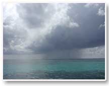 spotted
a waterspout out beyond the reef. Water spouts or sea spouts are caused
by unstable air masses. When they touch the water they actually pick up
water and anything in the water as well, including fish. A waterspout hit
San Pedro a few weeks ago. It cut a swath 16 feet through the island and
damaged a couple of planes. A small boat is certainly not safe when a water
spout is in the area.
spotted
a waterspout out beyond the reef. Water spouts or sea spouts are caused
by unstable air masses. When they touch the water they actually pick up
water and anything in the water as well, including fish. A waterspout hit
San Pedro a few weeks ago. It cut a swath 16 feet through the island and
damaged a couple of planes. A small boat is certainly not safe when a water
spout is in the area.
We quickly got on board and headed out of the area. Conditions change in
a heartbeat on any given day. Like all field researchers, Katie and Caryn
have to be prepared to change their plans—so we headed to Jane’s
Cove to do more scans and hopefully avoid the storm.
Attention Mrs. Braley's students in North Carolina—can
you name these clouds?
Jane’s Cove
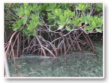 The
water at Jane’s Cove was like glass. Egrets and cormorants stood among
the
The
water at Jane’s Cove was like glass. Egrets and cormorants stood among
the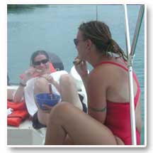 mangroves and a Magnificent frigate bird flew by. Snorkeling close to the
mangrove roots we could clearly see mangrove aerial prop roots. There are
raised bumps called lenticels on the roots, which is how the mangroves take
in air.
mangroves and a Magnificent frigate bird flew by. Snorkeling close to the
mangrove roots we could clearly see mangrove aerial prop roots. There are
raised bumps called lenticels on the roots, which is how the mangroves take
in air.
Lunch on the boat was last night’s leftovers—meatloaf and mashed
potatoes—served cold. We are starting to notice a trend here. What
we don’t finish for dinner, we eat for lunch the next day. The good
news is that we are not going hungry. Food is plentiful and thankfully,
tasty—even cold.
Filming Manatees
As we were heading out of Jane’s Cove we spotted a manatee and stopped
for an hour or more to observe it. The animal stayed submerged for ten minutes
at a time and when it came up for air, it took five breaths in less than
two minutes and then dove. We watched the manatee repeat this cycle three
times. Based upon the literature Caryn and Katie expected the animal to
be larger than what Caryn observed while in the water. There is some evidence
to suggest that the larger the animal, the longer it can stay underwater.
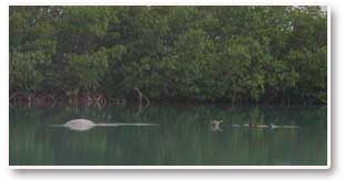 Caryn
got into the water with her underwater video camera and swam over to the
manatee. She was able to detect that the manatee was a female. The mouth
was covered with sediment indicating that the manatee had recently buried
her head in the mud. Manatees feed by pulling out seagrass plants by the
roots, eating the rhizomes and letting the rest float away. Yesterday we
spotted manatees that had mud on their faces but they were not in an area
where seagrass grows. There is some speculation from research done in Florida
that manatees may eat actually eat mud. Why? Nobody knows yet.
Caryn
got into the water with her underwater video camera and swam over to the
manatee. She was able to detect that the manatee was a female. The mouth
was covered with sediment indicating that the manatee had recently buried
her head in the mud. Manatees feed by pulling out seagrass plants by the
roots, eating the rhizomes and letting the rest float away. Yesterday we
spotted manatees that had mud on their faces but they were not in an area
where seagrass grows. There is some speculation from research done in Florida
that manatees may eat actually eat mud. Why? Nobody knows yet.
In the water Caryn didn’t see any remarkable markings on the manatee.
Once she and Katie watched the video back at camp they did see some scaring
on her back. That is one of the reason the video camera is so helpful in
their research. The video was beautiful. We could clearly see the manatee
do a paddle dive.
As we headed out Katie spotted a shark and another dolphin. A school of
mullet fish seemingly flew across the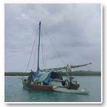 surface as they repeatedly leapt out of the water as they swam forward.
A fishing boat was sitting peacefully in the water. We stopped near the
base camp at Gilroy’s Lagoon and quickly laid out a compass grid and
collected four core sediment samples. The team is learning how to do the
work and the process went very efficiently. Tomorrow we will learn how to
process the seagrass samples back at the research station.
surface as they repeatedly leapt out of the water as they swam forward.
A fishing boat was sitting peacefully in the water. We stopped near the
base camp at Gilroy’s Lagoon and quickly laid out a compass grid and
collected four core sediment samples. The team is learning how to do the
work and the process went very efficiently. Tomorrow we will learn how to
process the seagrass samples back at the research station.
While the team was getting the samples Hannah was slowly swimming about
40 meters away when a large manatee approached her and swam near her for
several minutes. She remained still as the animal approached to within a
few inches of her. Hannah came up wide-eyed and very excited.
With the samples collected we motored back to base. Just before docking
Hannah spotted a small crocodile in our lagoon.
![]()